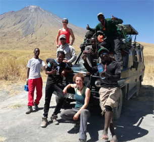
For five weeks in July and August 2019, the Deep Carbon Observatory (DCO) funded expedition sought to collect the first natrocarbonatite lava samples since the 2007 explosive eruption of Ol Doinyo Lengai volcano in Tanzania.
Kate Laxton, a PhD student in Earth Sciences at UCL (University College London), pictured front, describes Ol Doinyo Lengai as the world’s only remaining active carbonatite volcano, erupting the runniest and coldest lavas on Earth at less than 600 degrees C. The aim; to understand how it formed, why it’s still active and what caused its magma to become so unique. She adds: “However, it is also important to us to contribute towards safeguarding the livelihoods of the local Maasai community, from whom we can also learn a great deal by listening to generations-worth of observations and story-telling.”
Kate organised the project with support from the Geological Survey of Tanzania (GST) and the University of Dar Es Salaam. A practical question: how to communicate, rapidly if necessary, with the outside world, in a region with no mobile phone signal? “We were faced with being out of mobile coverage for up to three weeks in a remote region of northern Tanzania and wanted to ensure that our remote security team in England knew where we were at any one time. We were also keen to relay information back to the supervisory team at UCL in London and for our own peace of mind needed an emergency contact function – a quick and simple way of alerting the security team should urgent help be required.
“An internet search gave me and my UK-based team, Dr Emma Liu and Arno Van Zyl, a list of tracking providers. We selected Vismo because of its track record over many years in providing mobile comms for individuals and organisations around the world, some of them in the most demanding situations, from mountains in the Himalayas to remote rivers in South America. Those comms include Vismo’s technical expertise and server hardware, which together enabled the precise tracking of our location for use by our security team, and two-way communication with UCL.”
Vismo’s offering chosen by the expedition team – and recommended by the company for this project – was an Iridium Extreme satellite phone that includes the Vismo app. “Satellite phone signals reach remote areas that mobile phones can’t. And the app includes a panic button that, when pressed, sends an alert – with a live audio and video stream – to our security team,” says Kate.
“Thankfully, we never had to use it but we did use the app’s precise, GPS-based location function, allowing details of our location to be updated every 20 minutes for the duration of the project. That was reassuring for all of us, including our support crew.
“For the most part, we ended up using the satellite phone to update UCL via text message and perhaps more importantly for morale, occasionally snatching a moment to call home. Although, after becoming concerningly ill and deteriorating rapidly during the first ascent of Ol Doinyo Lengai, I was truly grateful to have a phone powerful enough to connect me through to emergency medical services in the UK, which saved me opting for a medical evacuation as my last resort.
“The data we collected during the expedition was logged by the on-board micro-controllers within our gas sensors, so there was no need to forward the data on to UCL at that stage but it was useful to know we had that capability as a back up.” The volcano had exploded in September 2007, only two weeks after the last lava sampling campaign. “We didn’t want to be caught up in a situation where we were in physical danger and unable to communicate with anybody,” she says.
Another reason for considering security was the proposed work at the volcano. Kate takes up the story. “The plan was simple; stretch a rope across the 300 metre wide crater at the summit of the volcano, and use a system of pulleys supplied by DMM Wales to send sampling cups, e.g. stainless steel cocktail shakers, straight into the open lava pool.
“Then, using the same rig, send a Multi-component Gas Analyser System (MultiGAS) down to the crater floor to measure volcanic emissions over time. A small number of custom-built CO2 sensors were also suspended independently of the main line, neatly packaged in glittery hamster balls to help them roll down the inner slopes of the crater. The point of which, once I get a handle on the data processing, is to provide a baseline for the current level of activity at Ol Doinyo Lengai from which scientists can track changes in the future.
“When we arrived at the summit, we were fortunate to find that the activity on the crater floor consisted of lava flows, an open lava pool and one spatter cone, giving us ample opportunity to proceed with our sampling strategy.
“By the end, we had spent eight days and nine nights at the summit, giving us enough time to collect six freshly erupted natrocarbonatite samples, six MultiGAS traverses, two MultiGAS dips, three nights of thermal imaging, three drone-based DEMs [digital elevation models] and eight tephra samples, all the while smashing our targets with a whole load of brilliant teamwork.”
Would Kate do it again? “Absolutely,” she says. “And I would always recommend we use a satphone-based solution for all of our communication and security needs.”
Photo courtesy of UCL.


